Geology and Significance of the Gold-bearing Gravels of the Sierra Nevada Mountains, California, According to CCC Model
© 2011
Geologic Events
CCC Model Explanation
Local Geologic Column
Great uplifting and tilting of the northern Sierra Nevada toward the west along the fault zones of the steeper eastern side. This mountain-building process causes a catastrophic release of the material behind the greenstone ridges, deeply eroding the landscape. Earthquakes still transform the landscape even today. Heavy snow accumulations produced glaciation during the Ice Age and, to a lesser extent, at various times since then.
Pleistocene/Recent
As a result of the cooling of the oceans after the Flood and further post-Flood adjustments, this area undergoes dramatic local change, paving the way for the modern world.
A series of volcanic eruptions and massive erosion of previously deposited "Tertiary" rocks. The narrow valleys fill with volcanic material and new river patterns form as a result. The volcanic material acts as a dam on the towering greenstone ridges and the narrow river channels through the greenstone ridges become closed.
Oligocene / Miocene / Pliocene
Later auriferous gravels
Mahrten Fm.
Valley Springs Fm.
The first major post-Flood volcanic activity begins in this area and dramatically changes the landscape and the life-style of the inhabitants. It signals what was soon to come: the further elevation of the Sierra Nevada Mountains and the onset of the Ice Age.
Period of relative geologic calm. Three topographic zones: (1) In the western foothills of the newly formed, low-lying, early Sierra Nevada Mountains, a belt of greenstone ridges rise up to 1,800 feet high, but crossed by rivers in narrow canyons; (2) to the east of the ridges, lowlands eroded on the slates of the Mother Lode belt, in which were cut river valleys; (3) east of the lowland, a broad plateau rising several thousand feet, incised several hundred feet by "Early Tertiary" stream river valleys. Abundant rainfall, perhaps up to 80 inches annually, with dense vegetation. Deposition of early gold-bearing gravels in river beds. Inhabited by early post-Flood humans with Neolithic Culture.
Eocene
Ione Fm.
Early auriferous gravels
The early post-Flood world saw the scattering of the descendants of Noah and his family. Boat travel seems to have been common, so great distances could be traveled with relative ease. This area of the world had much to offer early post-Flood humans and they seemed to thrive with a culture unmatched until nearly our time.
A period of violent activity. The marine sedimentary rocks are complexly faulted, strongly deformed and intruded by igneous masses. This seems to be the result of the North American plate moving 1500 miles westward over the edge of the Pacific Plate. Period of mountain building. At same time, enormous erosion occurs in the area of the future Sierra Nevada Mountains as many miles of overlying rocks are eroded off deeply buried granitic batholiths.
Events associated with the Genesis Flood Event (GFE) and rapid plate motion radically transform the area. Thousands of feet of strata are quickly eroded off the Plate Boundary region as earth movements transform it. This sets the stage for early post-Flood period when low-lying mountains and abundant rainfall create the initial, tropical "California" paradise.
Cretaceous / Upper Jurassic
Thousands of feet of sedimentary strata deposited on the ancient sea floor.
In the long, pre-Flood world, this area was west of the former continental boundary. The ocean bed developed thousands of feet of sedimentary rock during that time as a result of regional events due to the Curse.
Mesozoic / Paleozoic

Figure 1: Map of California, location of Calaveras County, the Sierra Nevada Mountains and the geologic cross-section (C — C’) of Figure 2.
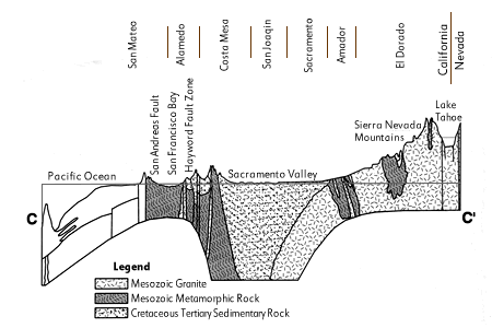
Figure 2: Geologic cross-section (C — C’) of California just north of Calaveras County from the Pacific Ocean to the border with Nevada (see Figure 1). Modified from the 1962 Geologic Highway Map of the AAPG.